California: The San Andreas Fault

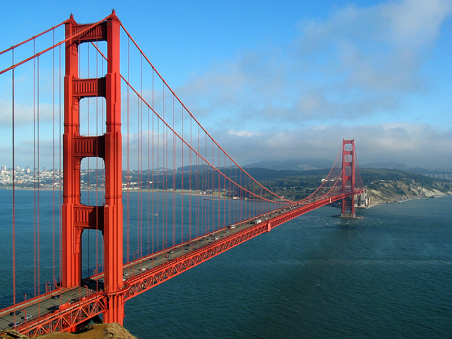
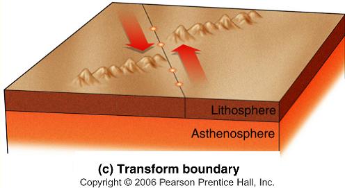
I’m now in San Francisco! Today I walked all the way across the Golden Gate Bridge. It was a really windy day, and I got pretty cold, but the view was really amazing! Did you know, the color of the bridge is actually the rust proofing that was supposed to go under the paint? Everyone liked the color so much, they decided to ditch the paint and keep it as it is today. San Francisco is also the site of a big earthquake that happened back in 1906. This brings me to my next topic, the San Andreas Fault. This is the boundary between the North American Plate and the Pacific Plate, and extends for about 810 miles through California and the US. The southwestern part of California is part of the Pacific Plate and is moving northwest, while the rest of the US is part of the North American Plate and is moving southeast. These two plates aren’t crashing into each other or moving apart from each other, but sliding past each other. This type of boundary is called a transform boundary. These types of boundaries don’t create mountains or volcanoes, but they do cause many earthquakes.


Picture Links:

http://www.cotf.edu/ete/modules/msese/earthsysflr/plates4.html

http://www.insurancejournal.com/news/west/2012/05/29/249179.htm

http://gomyclass.com/geology10/files/lecshare1/html/web_data/file52.htm

 ImageImageImage

Next Up: The Himalayas

I’ve moved on to visit the Himalayas, located on the border between Nepal and China. The weather here is very different from the warm, humid climate at my previous destination of the Mariana Islands. I very slowly made my way from Katmandu to the Base Camp of Mount Everest. The total height of the mountain being about 29,000 feet high, I decided not to risk my life as many before me have to venture to the summit. I instead hung around Base Camp (which is already 17,000 feet above sea level), watching the comings and goings of different hikers. It’s May, which is the best time to attempt a summit climb, as there are no startlingly low temperatures or hurricane force winds as there are in winter, but also no violent monsoons as there are in the summer. Mostly, I was eating vegetable stew, also known as Sherpa stew.

The Himalayas lie along a boundary where the Indian Plate is pushing north against the Eurasian Plate. The plate moves about 5 centimeters each year. The two continental plates have been welded together by the boundary, and are being forced upwards into a mountain range, the Himalayas. This type of boundary is called a collision boundary. As well as the mountain ranges that are being formed, many earthquakes occur as the plates push together.


Picture Links:

http://pubs.usgs.gov/gip/dynamic/understanding.html

http://en.wikipedia.org/wiki/Convergent_boundary

http://www.english-online.at/places/climbing-mount-everest/mountaineering-in-the-himalayas.htm

Mount Everest

Himalayan BoundaryImage

First Stop: The Mariana Islands

Hi guys, at the moment I’m on Guam, one of the Mariana islands located in the north-western part of the Pacific Ocean. Today I hiked up Mount LamLam, the highest point on the island. It took me a good half-day to hike all the way to the summit. At the top of the mountain, I got a beautiful 360 degree view of the entire island. It was, however, a very precarious perch at the summit, which is very windy and only large enough to fit one person. As a descended down the mountain, I happened upon a beautiful waterfall, where I stopped to rest before continuing back to the ground.

The elevation difference from Mount LamLam to the Mariana trench is about 38,300 feet, making it the largest gain of elevation on earth. Both the Mariana Islands and the Mariana Trench were formed from the boundary between the Pacific Plate and the Philippine Plate, both oceanic plates. This specific type of boundary is called an ocean-ocean subduction boundary. What happened here is that the Pacific Plate got pulled (or subducted) under the Philippine plate, forming a very deep ocean trench known as the Mariana Trench. On the Philippine Plate, which moved over the Pacific Plate, a chain of volcanic islands were formed, called the Mariana Islands. Both a deep-sea trench and volcanic islands are formed at the area of an ocean-ocean subduction boundary.

Picture Links:

http://web.gccaz.edu/~lnewman/gph111/topic_units/plates/plates2.html

http://touroftheearth.blogspot.com/2011_04_01_archive.html

http://en.wikipedia.org/wiki/History_of_Guam

Guam

ImagePhilippine-Pacific Plates

Hello!

Hey everybody, and welcome to my plate tectonics blog! I’ll be posting at each location I visit as I explore the world of plate boundaries. Along the way, we’ll learn the different boundary types, how they work, and the characteristic features of each boundary type. Stay tuned for more posts!

-Isabelle