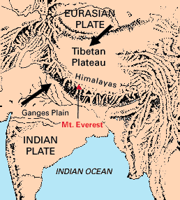
I’ve moved on to visit the Himalayas, located on the border between Nepal and China. The weather here is very different from the warm, humid climate at my previous destination of the Mariana Islands. I very slowly made my way from Katmandu to the Base Camp of Mount Everest. The total height of the mountain being about 29,000 feet high, I decided not to risk my life as many before me have to venture to the summit. I instead hung around Base Camp (which is already 17,000 feet above sea level), watching the comings and goings of different hikers. It’s May, which is the best time to attempt a summit climb, as there are no startlingly low temperatures or hurricane force winds as there are in winter, but also no violent monsoons as there are in the summer. Mostly, I was eating vegetable stew, also known as Sherpa stew.
The Himalayas lie along a boundary where the Indian Plate is pushing north against the Eurasian Plate. The plate moves about 5 centimeters each year. The two continental plates have been welded together by the boundary, and are being forced upwards into a mountain range, the Himalayas. This type of boundary is called a collision boundary. As well as the mountain ranges that are being formed, many earthquakes occur as the plates push together.
Picture Links:
http://pubs.usgs.gov/gip/dynamic/understanding.html
http://en.wikipedia.org/wiki/Convergent_boundary
http://www.english-online.at/places/climbing-mount-everest/mountaineering-in-the-himalayas.htm


